What does exist is a filed envelope, and that envelope is more informative than most marketing site plans. This page works from three things and keeps them separate throughout: the verified figures in the developer's own environmental filing and in KIADB's layout documents; the unconfirmed tower, floor and unit figures carried in the project information supplied to us; and our own arithmetic, shown in full and labelled as an estimate. Anyone who wants a land-use pie chart for this parcel will have to wait for the sanctioned plan, and should be sceptical of any site that publishes one today.
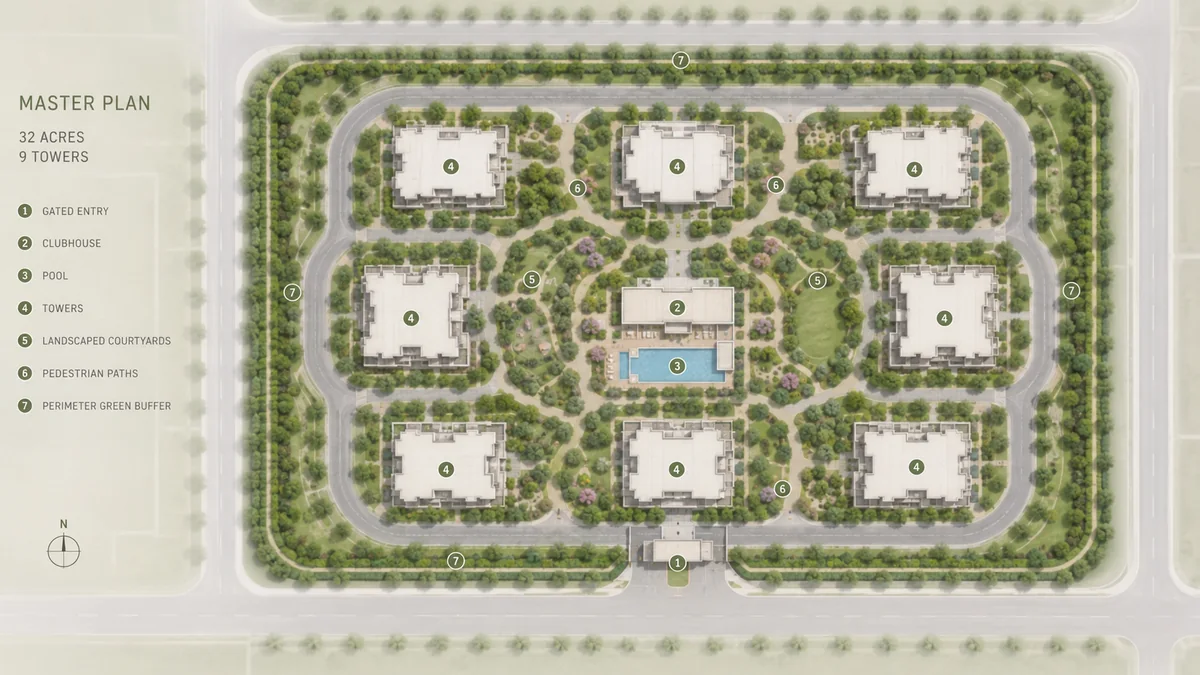
What Is on Record, and What Is Not
| Item | Position |
|---|---|
| Land area | 32.26 acres (13.0552 ha) — verified, from the developer's environmental filing |
| Plot schedule | Plot Nos. 13, 14-P, 14-P1, 19-P, 19-P1, 20, 24 and Road No. 8 — verified |
| Proposed built-up area | 3.84 million sq ft (357,097 sq m) — verified |
| Stated project cost | ₹877 crore — verified |
| Filing category | EIA item 8(b), Area Development; titled a Residential & Commercial Development — verified |
| Tower count, floor count, unit count | From the project information supplied to us — not in any filing |
| Land-use split, open space, podium levels, parking bays | Not published anywhere |
| Sanctioned plan | None on record |
The distinction matters commercially, not just editorially. The filed envelope is a number the developer has committed to a statutory authority and cannot casually revise; the tower and unit figures are pre-launch marketing inputs that routinely change between first circulation and RERA registration.
The Land Position
The parcel is 32.26 acres inside the KIADB Hi-Tech Defence & Aerospace Park Phase-2, held on a KIADB allotment — the ownership document recorded in the filing is an allotment letter, not a sale deed. Material in circulation describes a site of about 12 acres. The filed figure of 32.26 acres contradicts it, the mapped site polygon independently measures 32.29 acres, and the filed figure is the one this site uses.
Two features of the plot schedule are worth reading carefully. First, several plots are part-plots — 14-P, 14-P1, 19-P, 19-P1 — which means the parcel was assembled from subdivided KIADB allotments rather than taken as a single block. Second, the schedule includes Road No. 8, a numbered road in the KIADB layout. Our reading of that is that a laid-out estate road runs into or through the assembled parcel and has been included in the allotment, which would let the scheme be planned as one continuous site rather than as two blocks split by a public road. That is an inference from the plot schedule, not a statement from the filing.
For context on what surrounds it, KIADB's own pre-feasibility report divides the wider 1,210.85-acre layout between industrial, commercial, amenity, utility, park and green buffer, parking and road uses. There is no residential line item in that table, and its entire commercial allocation of 26.92 acres is smaller than this one parcel. The developer has nonetheless filed the scheme as a Residential & Commercial Development. The zoning question is genuinely open.
Floor-Area Ratio — the Arithmetic
This is the most useful thing the filing gives us, because it puts a hard ceiling on how intensively the parcel can be built.
32.26 acres × 43,560 sq ft = 1,405,246 sq ft of land
357,097 sq m × 10.7639 = 3,843,780 sq ft of proposed built-up area
| Measure | Working | Result |
|---|---|---|
| FAR on total filed built-up area | 3,843,780 ÷ 1,405,246 | 2.74 |
| FAR excluding basements (assumed ≈25% of built-up) | 2,882,835 ÷ 1,405,246 | ≈2.05 |
Karnataka raised the FAR available on KIADB industrial land from 3.25 to 5.2. The environmental clearance for the adjacent Brigade parcel records 3.25. A scheme sitting near 2.05 above ground is therefore well inside both the current allowance and the nearest neighbour's benchmark.
That is a genuinely positive, checkable point, and it is the opposite of what pre-launch material for this project implied. Nothing about this envelope is aggressive. A developer building to 2.05 where 5.2 is available either intends to phase the parcel over time, or is choosing lower coverage and more ground plane, or both. The 25 per cent basement assumption is a convention for a scheme with two basement levels, not a filed figure; change it and the above-ground FAR moves, but not the conclusion.
How Many Homes the Envelope Supports
The project information supplied to us gives approximately 1,800 apartments. Set that against the filed envelope and the two do not describe the same thing.
| Step | Working | Result |
|---|---|---|
| Filed built-up area | 357,097 sq m × 10.7639 | 3,843,780 sq ft |
| Saleable share, assuming two basement levels, services and clubhouse are excluded | ≈65% | ≈2,500,000 sq ft |
| Weighted average unit size at the circulating mix (30% × 550 + 45% × 900 + 25% × 1,550) | — | 958 sq ft |
| Apartments the envelope supports | 2,500,000 ÷ 958 | ≈2,600 |
| The figure in circulation | — | 1,800, about 69% of that |
Both assumptions are ours and are named: the 65 per cent saleable-to-built-up ratio is a convention, not a filed number, and the 30/45/25 mix is our own reading of a one-to-three-bedroom ladder with no four-bedroom unit. Move either and the count moves; the direction of the finding does not.
The reconciliation the evidence favours is that 1,800 describes the phase currently in the market, and the filed envelope covers a larger scheme. That is exactly what a filing named "Holland & Battersea" and categorised as an Area Development suggests — two schemes, one parcel, one clearance.
A second, independent signal points the same way. The filing states an operational permanent employment of 9,914 posts, against only 50 during construction. Facilities, security and management for 1,800 homes would run in the low hundreds. A figure near ten thousand is a workplace number, and it belongs to the commercial half of a filing that is explicitly titled a Residential & Commercial Development. Two conclusions follow: this parcel very probably carries a substantial commercial or office component alongside the apartments, and the apartment figure in circulation describes only part of what has been filed. Neither the split nor the commercial floor area has been published.
Density and Ground Coverage
At the filed acreage the density is modest.
1,800 apartments ÷ 32.26 acres = ≈56 apartments per acre
For comparison, the 75-acre Brigade township 1.38 kilometres away runs at roughly 96 per acre. The alarming figure that circulated for this project — around 150 per acre, roughly double its neighbours — was an artefact of the 12-acre land area, not of the scheme. On the filed acreage the density concern closes.
Ground coverage can be estimated the same way, and the result is worth stating because it explains what a 32-acre site with a 2.05 above-ground FAR actually looks like.
If the phase is 1,800 apartments across nine towers, that is 200 apartments per tower.
Across ground plus 25 upper floors, that is roughly 7.7 apartments per floor plate.
At a 958 sq ft weighted average, a plate carries ≈7,375 sq ft saleable, or roughly 9,000–10,000 sq ft gross once cores, lobbies and corridors are added.
Nine plates ≈ 81,000–90,000 sq ft = 1.9–2.1 acres, about 6 per cent of the parcel.
Tower footprint of roughly six per cent leaves an enormous ground plane. That is our estimate built on the unconfirmed tower and floor counts, so treat it as an order of magnitude rather than a specification — but the order of magnitude is what matters. Even doubling the built form to cover the full ≈2,600-apartment envelope would put tower footprint in the low teens as a percentage.
What that ground plane becomes has not been published. It is not automatically landscape. On a parcel filed as a Residential & Commercial Development with a workplace component large enough to imply thousands of jobs, a material share of the open ground may carry commercial blocks, service yards and visitor parking. No open-space percentage should be quoted for this project by anyone, including us, until a plan is sanctioned.
Towers, Floor Plates and Height
The project information supplied to us describes nine towers of two basements plus ground plus 25 upper floors. Nothing in any filing corroborates that, and the tower count is among the figures most likely to change before registration.
Height, however, is not a free variable here, and this is the approvals question that pre-launch material for the project does not raise at all. The site sits 4,637 metres beyond the eastern threshold of Runway 09L/27R, with a lateral offset of only 521 metres from the extended centreline. The approach surface at that distance has a half-width of 837 metres, so the site is inside the approach funnel.
Working the generic ICAO Annex-14 surfaces at that distance:
| Surface | Working | Ceiling above runway-end elevation |
|---|---|---|
| Approach surface | first 3,000 m at 2% = 60.0 m; remaining 1,577 m at 2.5% = 39.4 m | ≈99.4 m |
| Take-off climb surface (the binding one) | 0.02 × 4,637 m | 92.7 m |
| A two-basement, ground-plus-25 tower | 26 levels at 3.0–3.2 m floor to floor, plus lift overrun and parapet | ≈78–85 m |
On that arithmetic the described building fits, with little headroom. This is our derivation from generic obstacle-limitation surfaces, not the Airports Authority of India's number, and the permitted height at these coordinates is AAI's to determine and nobody else's. An AAI height No Objection Certificate is mandatory here regardless of the height proposed, because the site is 6.61 kilometres from the airport reference point and the 2015 Height Restrictions Rules require one anywhere within 20 kilometres.
The practical consequence for the master plan is real: if AAI's assessment comes back tighter than the generic surfaces suggest, the scheme absorbs it either by losing floors — which pushes footprint outward and eats ground plane — or by adding towers. Either way the layout changes. This is one reason to treat any tower-placement drawing circulating before the NOC as provisional.
Roads, Circulation and the Approach
The parcel's external circulation depends on infrastructure that is still being built. Within 1.5 kilometres of the site, OpenStreetMap records 169 road segments — 55 tagged as under construction and 138 with no surface recorded. Only twelve carry a name, and all twelve are the Satellite Town Ring Road. The KIADB Phase-2 internal grid is being laid rather than finished, so the estate roads a completed scheme would connect to are, in several cases, not yet complete.
Internally, nothing has been published: no gate positions, no driveway widths, no basement ramp locations, no fire-tender access loop. What can be said from the geometry is that a 32-acre site with roughly six per cent tower footprint has enough room to grade-separate vehicles from pedestrians properly — to run a peripheral vehicular loop with basement ramps at the edges and keep the centre of the site free of traffic — rather than being forced into the compromised single-driveway arrangements that small urban parcels produce. Whether the design takes that option is unknown.
One question belongs on the list when a plan finally exists: whether the KIADB estate roads the site connects to will be complete at handover. On an industrial layout those roads are KIADB's to build and maintain, and their schedule is not the developer's to control.
Below-Ground Infrastructure
The project information describes two basement levels, and the FAR arithmetic gives a sense of how large they would be.
Assumed basement share of built-up area: ≈25% of 3,843,780 sq ft = ≈960,900 sq ft
Across two levels: ≈480,500 sq ft per level ≈ 11.0 acres, or roughly a third of the parcel's footprint
Parking capacity at ≈350 sq ft per bay including aisles and ramps: ≈2,700 bays
Two things follow. The first is that the numbers are internally coherent — a two-level basement of about 11 acres per level is what a scheme of this built-up area on this parcel would need, which is a useful check that the filed figures hang together. The second is that roughly 2,700 bays against an envelope supporting ≈2,600 apartments plus a commercial component large enough to imply thousands of jobs is tight. Parking is very likely to be one of the harder problems on this site, and it is a fair question to ask before committing to a unit.
A basement of that footprint does carry a design upside: it puts most of the parking below grade, freeing the ground above for landscape and podium-level amenity rather than surface car parks. That is the normal outcome for a scheme built this way, though nothing published confirms it here.
Water, Waste and Energy
The amenity schedule supplied to us lists a sewage treatment plant, rainwater harvesting, two levels of basement car parking and power backup for common areas — every item marked indicative, with no capacity, no bay count and no percentage attached to any of them. No solar provision appears in the material at all. None of it should be read as a specification.
These are not decorative items on this particular parcel, because of where it sits. Devanahalli has no perennial surface water source and no Cauvery supply; the region is officially classified over-exploited for groundwater, with Devanahalli reported at around 169 per cent of its permissible extraction. Cauvery Stage VI, approved by the Karnataka cabinet in February 2026, is at planning stage with the earliest supply discussed around 2028. And on KIADB-allotted land, water supply is KIADB's responsibility rather than BWSSB's, so a completed scheme here draws on the board's bulk arrangements and on its own borewells, storage and recycled water.
That makes the sewage treatment plant's capacity, the share of treated water returned to flushing and irrigation, the rainwater harvesting design and the raw-water storage volume the most consequential engineering decisions on this master plan — more consequential than the clubhouse. It is also precisely where they get scrutinised: the Terms of Reference and environmental impact assessment process for an item 8(b) Area Development is the stage at which water balance, wastewater treatment, solid waste handling and energy conservation measures are examined and made conditions of clearance. That process began on 11 August 2026 and has not yet produced a Terms of Reference, let alone a clearance. The commitments do not exist yet because the mechanism that fixes them has not run.
What to Ask For, and When
Until a plan is sanctioned and the project is registered, the honest summary of this master plan is that the parcel is large, the filed envelope is comfortable rather than strained, and the building on it has not been designed in public. Four documents will settle everything on this page, and none of them is available today: the granted Terms of Reference and environmental clearance, which fix the water, waste and energy commitments; the AAI height No Objection Certificate, which fixes how tall the towers can be and therefore how many there are; the sanctioned building plan, which fixes land use, coverage, open space and circulation; and the Karnataka RERA registration, which publishes the approved plans, the unit schedule and an enforceable completion date.
Prestige Park Lane KIADB is not registered with Karnataka RERA and no application for it has been filed. Under Section 3 of the Real Estate (Regulation and Development) Act 2016, no scheme of this scale may be promoted, reserved or conveyed ahead of registration, so until a number is issued there is nothing a buyer can lawfully pay against. Verify the position yourself at rera.karnataka.gov.in.
Prestige Park Lane KIADB Master Plan FAQs - Frequently Asked Questions
What is KIADB approval, and how does it differ from BDA or BBMP approval?
The Karnataka Industrial Areas Development Board acquires land, lays out industrial areas and allots plots within them to industrial and allied users. A KIADB layout is a notified industrial area, planned and serviced by KIADB rather than by a city planning body, and plan sanction inside it ordinarily rests with KIADB. That is a different framework from a BDA-approved layout or a BBMP-sanctioned building inside the city corporation. For a homebuyer the differences show up in tenure, in permitted land use, and in who is responsible for water, roads and services - which here is KIADB, not BWSSB.
Is KIADB-allotted land a sound basis for a residential purchase?
It is a genuinely open question on this parcel, and buyers should treat it as one. The developer's own filing records the ownership document as an allotment letter, not a sale deed, which is a different tenure from private freehold. KIADB's own pre-feasibility report for this industrial area allocates no acreage at all to residential use across the entire 1,210.85-acre layout, with the whole commercial allocation smaller than this single 32.26-acre parcel, yet the developer has filed the scheme as a Residential and Commercial Development. There is precedent inside the wider park - Brigade's 75-acre township holds Plots 305-309 in this same layout - but the position here is unresolved, so ask to see the allotment letter and the land use recorded on it.
How many apartments, towers and floors are planned, and how dense is that?
The project information supplied to us describes approximately 1,800 apartments across nine towers of two basements plus ground plus 25 upper floors. None of those figures appears in a filing, a sanctioned plan or a registration, so treat them as that source's claim rather than settled fact. Spread over the filed 32.26 acres, 1,800 homes works out at about 56 per acre - our arithmetic - materially lower than the roughly 96 per acre of the neighbouring township. The same arithmetic on the 12-acre figure that also circulates would give 150 per acre, which is why the acreage question matters.
What configurations and unit sizes are planned?
The project information supplied to us describes a compact ladder of 1, 2 and 3 BHK with no 4 BHK: the 1 BHK at 550 to 650 sq ft super built-up, the 2 BHK at 800 to 1,000 sq ft, and the 3 BHK at 1,400 to 1,800 sq ft. No sanctioned plan or registered unit schedule exists to confirm any of these, and carpet areas have not been published, so the bands cannot yet be converted into usable floor area. What is notable is the absence of a large format at the top and a genuine compact unit at the bottom, which points at a different buyer from the township product elsewhere in the belt.
What is the expected price per square foot in this pocket of Devanahalli?
The branded apartment comparables in the belt cluster tightly. Ebony at Brigade Orchards is developer-published at Rs 10,260 per sq ft under Karnataka RERA number PRM/KA/RERA/1250/303/PR/280225/007530, and Purva Northern Lights at KIADB Bagalur at Rs 11,000 under registration reference PR/120326/008523. Laurel & Maple at Brigade Orchards is reported at Rs 11,480 with a senior-living premium, and Provident Ecopolitan at Rs 10,600, Godrej MSR City at Rs 10,050 and Sattva Vasanta Skye at Rs 9,800 complete the set, giving a mean of Rs 10,532. The delivered-township tier of Birla Trimaya, Tata Carnatica and Lodha Sadahalli sits higher at Rs 12,500 to Rs 13,250, and we set our ceiling below it because no delivered township surrounds this parcel.
What should I verify for myself before committing anything?
Four checks, in order. Search rera.karnataka.gov.in for the project, for Prestige Holland, for Prestige Battersea and for Apex Realty Management Private Limited, and confirm a registration exists before any money moves. Ask for the KIADB allotment letter and the permitted land use recorded on it, and for the survey numbers, so they can be checked against the Special Agricultural Zone order of 6 December 2025. Track PARIVESH proposal SIA/KA/INFRA2/588626/2026 for the Terms of Reference grant and the clearance that follows. Then take independent legal advice on the allotment tenure, because it is not the freehold title most apartment buyers are used to.